Pleistocene Glacial Maximum
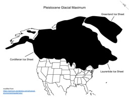
Map of North America showing US states and Canadian provinces and the extents of the Laurentide, Greenland, and Cordilleran ice sheets at the Pleistocene glacial maximum
Download PDF Download PPTX- Tags
- maps, glaciers
- Creator
- Kent Ratajeski, University of Kentucky, kent.ratajeski@uky.edu
- Source
- https://opinicon.wordpress.com/physical-environment/quaternary/, https://www.worldatlas.com/webimage/countrys/namerica/naoutl.htm
- Language
- Grade 2 (contracted) Braille
- Font
- Swell Braille, 24 pt, download from https://www.tsbvi.edu/download-braille-and-asl-specialty-fonts

This work is licensed under a Creative Commons Attribution 4.0 International License.