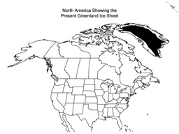
North America Showing Present Greenland Ice Sheet

Map of North America showing US states and Canadian provinces and the present extent of the Greenland ice sheet
Download PDF Download PPTX- Tags
- maps, glaciers
- Creator
- Kent Ratajeski, University of Kentucky, kent.ratajeski@uky.edu
- Source
- https://www.worldatlas.com/webimage/countrys/namerica/naoutl.htm
- Language
- Grade 2 (contracted) Braille
- Font
- Swell Braille, 24 pt, download from https://www.tsbvi.edu/download-braille-and-asl-specialty-fonts

This work is licensed under a Creative Commons Attribution 4.0 International License.